Vantor Introduces First-of-a-Kind Expansion of Its Satellite Constellation Combining High-Resolution Imaging and Real-Time Global Monitoring
April 09, 2026
-Vantor, the leading provider of unified spatial intelligence, today announced plans to expand its industry-leading satellite constellation and create the first commercial space-based system combining accurate, high-resolution imaging with real-time global monitoring—empowering government and commercial customers to generate intelligence and power tactical operations at unprecedented speed and scale.
For decades, space-based intelligence has forced a tradeoff: you could either see the world in high detail or monitor it continuously, but not both. This expansion to Vantor’s constellation, which already delivers the most accurate and high-resolution imagery on orbit, eliminates that tradeoff for the first time.
The new architecture introduces the addition of two satellite systems:
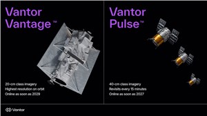
- Vantor Vantage™, next-generation 20 cm-class imaging satellites delivering the highest commercial resolution on orbit.
- Vantor Pulse™, a fleet of 40 cm-class satellites designed for persistent, high-frequency monitoring.
These new satellites build on the success of Vantor’s state-of-the-art WorldView Legion program, which doubled collection capacity, introduced dawn-to-dusk monitoring, and set a new benchmark for commercial imaging performance. Legion satellites are already supporting high-priority missions for customers around the world, delivering the scale, accuracy, and reliability required for operational missions.
With Legion, Vantor’s constellation can collect over 3.5 million square kilometers of highly accurate 30 cm-class imagery daily and revisit the same location on Earth up to 15 times per day. The expanded fleet will further increase this collection capacity while improving revisit rates five-fold, unlocking imaging of the same location on Earth as frequently as every 15 minutes.
These capabilities enable a continuously updated, real-time view of the world in 2D and 3D—allowing customers to detect change, maintain up-to-date maps, track activity, and predict emerging threats at machine speed.
Vantor expects to bring the first Pulse satellites online as soon as 2027, followed by the first two Vantage satellites as soon as 2029.
“Vantage and Pulse usher in a new era of space-based intelligence—it’s the first time that governments and businesses can get both detailed imaging and real-time monitoring from a single commercial system,” said Dan Smoot, Vantor CEO. “That fundamentally changes how intelligence is generated and used. Instead of choosing between accuracy and speed, customers can seamlessly collect, fuse, and deploy our multi-class intelligence within their sovereign systems, turning space-based data into a real-time operational capability.”
Fueling Tensorglobe, Vantor’s end-to-end platform for real-time intelligence
Modern defense and intelligence missions require real-time sovereign intelligence systems, where data is continuously collected and delivered directly into workflows customers fully own and control. Tensorglobe™, Vantor’s end-to-end spatial intelligence platform, already drives this cycle today—and Vantage and Pulse will further accelerate its capabilities.
Tensorglobe integrates data from space, air and ground to create a fused spatial foundation natively accessible to geospatial AI models. This unified system automates the full intelligence cycle within a customer’s sovereign environment, from collection to analysis and delivery.
Tensorglobe powers a range of sovereign missions, including:
- Persistent monitoring: Enabling sovereign intelligence systems and applications like Sentry™ to automatically detect changes across hundreds of locations simultaneously with faster alerting and higher confidence.
- Time-sensitive tactical operations: Delivering continuously updated ground truth for any location on Earth, allowing commanders and warfighters to understand activity, make decisions, and act first based on the most current view of the environment.
- Autonomous systems: Powering Raptor™ with a continuously refreshed 3D operational terrain, enabling more accurate GPS-denied navigation and coordinate extraction in secure, sovereign environments.
The expanded constellation enhances the this system by increasing the frequency and freshness of the 2D and 3D spatial foundation that feeds Tensorglobe.
By combining accurate imaging, continuous monitoring, and sovereign deployment in a single system, Vantor is setting a new standard for space-based intelligence that empowers customers to move faster, operate with confidence, and maintain a real-time understanding of dynamic mission environments.
Source : Vantor
Related Studies