New Sea-level Monitoring Satellite Goes Live
June 21, 2021
-Following liftoff last November and more than six months spent carefully calibrating the most advanced mission dedicated to measuring sea-level rise, Copernicus Sentinel-6 Michael Freilich is now operational – meaning that its data are available to climate researchers, ocean-weather forecasts and other data users.
Sentinel-6 is one of the European Union’s family of Copernicus missions but its implementation is the result of an exceptional cooperation between the European Commission ESA, Eumetsat, NASA and NOAA, with contribution from the CNES French space agency. The mission comprises two identical satellites launched five years apart: Copernicus Sentinel-6 Michael Freilich launched on 21 November 2020 and Copernicus Sentinel-6B, which will be launched in 2025.
Sea-level rise is a key indicator of climate change so accurately monitoring the changing height of the sea surface over decades is essential for climate science, for policy-making and, ultimately, for protecting the lives of those in low-lying regions at risk.
Using the latest radar altimetry technology, developed by ESA, this new mission will advance the long-term record of sea-surface height measurements that began in 1992 by the French–US Topex-Poseidon satellite and then the Jason series of satellite missions.
Sentinel-6 Michael Freilich will soon pick up the baton and extend this dataset – a dataset that is the ‘gold standard’ for climate studies.
Julia Figa Saldana, ocean altimetry programme manager at Eumetsat, said, “We have been flying Copernicus Sentinel-6 Michael Freilich on the same orbit as the current altimetry reference mission, Jason-3, for the past six months so that the satellites have the same ‘view’ of the ocean.
“Experts from around the world have collaborated intensively over the past six months, despite the workplace constraints caused by the coronavirus pandemic, to cross-calibrate their data to ensure accuracy. The data are now being processed at Eumetsat in Darmstadt, Germany, from where the satellite is also being controlled, and from where the data are released to ocean and weather forecasting users.”
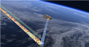
Craig Donlon, ESA’s Sentinel-6 mission scientist, said, “Building on a long line of European heritage dual-frequency altimeter missions, Sentinel-6’s Poseidon-4 altimeter was designed to bring new high-resolution Ku- band synthetic aperture radar measurements into the altimetry reference time series.
“To manage the transition from Jason-3’s lower resolution measurements to Sentinel-6’s high-resolution products with confidence, Poseidon-4 acquires both conventional low-resolution measurements simultaneously with high-resolution synthetic aperture radar measurements. The high-resolution products will be available later this year. We are really pleased to see that the data from Sentinel-6 show great performance based on validation by independent measurements on the ground.”
The Permanent Facility for Altimetry Calibration on the island of Crete in Greece is home to a transponder (CND1) that is key to this validation, ensuring that Sentinel-6’s low-resolution data are the same as that of Jason-3. The transponder receives the Sentinel-6 radar signal, which is amplified and transmitted back to the satellite providing a well-characterised external calibration source.
Dr Donlon explained, “Measurements from the CDN1 transponder show that the absolute difference between measurements from Sentinel-6 and Jason-3 is less than 2 mm, which is remarkable for two independent satellites operating at an altitude of 1330 km.
“Establishing the differences between Sentinel-6 and Jason-3 is important if stability in the sea-level rise time series from satellite altimetry is to be maintained with low uncertainties.”
Nadya Vinogradova-Shiffer, NASA program scientist for Sentinel-6 Michael Freilich, said, “The release of this data marks the beginning of a new Sentinel era of ocean satellite altimetry for the NASA science community and the international Ocean Surface Topography Science Team, who are excited, ready, and eager to expand nearly three decades of discoveries in ocean and climate science.”
As of 22 June 2021, two data streams of low-resolution sea-surface height are available to the public. The first is available within hours of Sentinel-6’s Poseidon-4 altimeter collecting it and the second stream comes a couple of days after it is acquired. The difference in when the products become available balances accuracy with delivery timeliness for tasks like forecasting the weather or helping to monitor the formation of hurricanes.
The third data stream, which is slated for distribution later this year or early next year, will be the most accurate.
European Commission’s Director for Space, Matthias Petschke, said, “Preparing our resilience and adapting to sea-level rise as an effect of climate change is a top priority in the decades to come, as part of the European Green Deal. From scenarios published in 2015 for Cop21, we can observe that the sea-level rise phenomenon is accelerating faster than expected. It will affect our EU coasts in decades to come, this is a certainty, and this is critical for some European countries.
“Jason missions, in the past, and now Copernicus Sentinel-6, are unique solutions to give us accurate information on this trend, observing and monitoring it accurately, as well revealing this alarming acceleration of the rise.”
Source : European Space Agency (ESA)