MetOp 2nd Generation Weather Satellite Pair Show Off
November 15, 2023
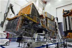
-Having satellites in different types of orbit is essential to delivering data to forecast the weather accurately. With the first Meteosat Third Generation Imager satellite safely in geostationary orbit since December 2022, it’s also time to focus on its polar-orbiting cousin, the MetOp Second Generation mission. And now, for the first time, two MetOp Second Generation satellites have been brought together to stand side-by-side for testing.
As its name suggests, the MetOp Second Generation mission, or MetOp-SG for short, will follow-on from the first series of MetOp satellites, which currently provide meteorological observations from polar orbit, and which have had the biggest impact on the accuracy of numerical weather prediction.
The Meteosat satellites, which hover 36 000 km above the equator in geostationary orbit, can monitor rapidly evolving events for now-casting and short-term weather prediction. However, being fixed above the equator means and that some parts of Earth are never viewed.
The MetOp satellites, on the other hand, orbit Earth from pole to pole and much lower down at an altitude of 832 km, allowing them to achieve global coverage every few days and make more detailed observations.
The complementarity of having satellites in both geostationary and polar orbits is key to accurate weather forecasting.
Comprising six satellites in total, the new MetOp-SG mission is based on a pair of satellites, type-A and type-B, that carry different instruments. The series is set to deliver a wealth of meteorological information for over 20 years.
The main reason why MetOp Second Generation has been designed to work as a pair is because the instruments needed are so large that it takes two satellites to accommodate them.
Each pair of satellites carries a total of ten instruments. The instruments are either significantly improved versions of those on the first generation or completely new, to provide measurements of unprecedented accuracy – not only for numerical weather prediction, but also for nowcasting at high latitudes, climate monitoring, atmospheric chemistry, oceanology, hydrology, and land applications.
The first MetOp-SG-A satellite has been at Airbus’ facilities in Toulouse, France, for about a year now, but it was recently joined by the first MetOp-SG-B satellite for a series of tests.
ESA’s MetOp-SG Project Manager, Marc Loiselet, said, “Having the first MetOp-SG-A and MetOp-SG-B in the same cleanroom is a unique opportunity to admire both satellites and their range of instruments, all of which have been developed and manufactured in Europe.”
“The A-type satellite carries instruments that image in the ultraviolet, visible and infrared wavelengths, and atmospheric sounders that work in the infrared and microwave frequencies.”
The METimage instrument, provided by the DLR German Aerospace Center, will provide very accurate 2D images of clouds sensed in infrared and visible bands.
IASI-NG, provided by the CNES French Space Agency, is an infrared sounder to provide 3D maps of atmospheric temperature and humidity as well as a spectrum of many different chemicals.
In addition, the Microwave Sounder will provide 3D maps of atmospheric temperature and humidity by taking observations in the microwave frequency range.
The 3MI instrument will be used to assess the impact of the aerosols on meteorology.
An instrument called Radio Occultation, which by tracking satellite navigation systems including Galileo, will provide very accurate vertical profiles of temperature and humidity. This instrument is accommodated on both A-type and B-type satellites.
The A-type satellite also carries the Copernicus Sentinel-5 mission to monitor air pollution and atmospheric ozone.
“The B-type satellites will provide images in the microwave and makes observations of ocean-surface winds and soil moisture,” added Marc Loiselet.
The Microwave Imager will provide images of precipitation and clouds as well as profiles of water vapour. The Ice Cloud Imager will, for the first time, provide images of ice clouds, which impact Earth’s radiation budget and so far not yet accounted for.
The scatterometer will provide ocean surface wind vectors and soil moisture. The final payload is the ARGOS-4 data collection system to collect data from various transmitters on Earth’s surface, in the sea and in the air.
The MetOp-SG mission is a cooperation between Eumetsat and ESA. ESA is responsible the development of the first two satellites and, on behalf of Eumetsat for the procurement of the four recurrent satellites. Eumetsat defines the overall system and user requirements, develops the ground systems, procures the launch services, operates the satellites, and makes the data available to users.
The mission is also the European component of the Joint Polar System – a collaboration between Eumetsat and the U.S. National Oceanic and Atmospheric Administration.
Both organisations’ polar-orbiting satellites bring benefits to weather forecasting and climate monitoring all over the world.
With Airbus as prime contractor, more than 110 companies in 17 countries are involved in building the MetOp-SG satellites. The first satellite-A and satellite-B will both be ready for launch in 2025, although the actual dates for liftoff are yet to be confirmed.
The MetOp-SG satellites are also the first European satellites designed for a controlled reentry at the end of their life in orbit. This was initiated ahead of the implementation space debris mitigation regulation.
You have already liked this page, you can only like it once!
Source : European Space Agency (ESA)