L3Harris High-Resolution Weather Instrument Set to Launch March 1 on NOAA's GOES-T Satellite
February 24, 2022
-L3Harris Technologies’ (NYSE:LHX) third high-resolution weather instrument is set to launch March 1 onboard a NOAA satellite – strengthening the nation’s ability to monitor the environment and rapidly detect severe weather.
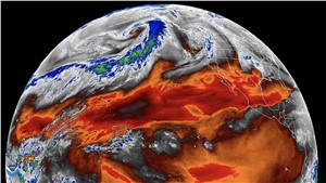
The Advanced Baseline Imager (ABI) is the primary instrument for the Geostationary Operational Environmental Satellite-T (GOES-T), the third in a series of four advanced geostationary weather satellites with L3Harris' ABI onboard. The ABIs are controlled by L3Harris' enterprise ground system.
The ABI provides high-resolution video of weather and environmental systems using 16 spectral bands delivering three times the amount of spectral coverage, four times the resolution and five times faster than the previous generation of GOES satellites. The Advanced Baseline Imagers on NOAA's two current geostationary operational satellites, GOES-East and GOES-West, enable more accurate meteorological forecasts, greater ability to study and monitor climate change, and allow experts to provide early warnings of severe weather conditions such as tornadoes, wildfires, and hurricanes.
“L3Harris' ABI has helped NOAA improve detection of wildfires, tornadoes and other extreme events that threaten lives,” said Rob Mitrevski, Vice President and General Manager, Spectral Solutions, Space and Airborne Systems, L3Harris. “We have been pioneers in space-based weather monitoring for more than 60 years and continue to set a high standard of capability with our Advanced Baseline Imager. We look forward to driving further forecasting advancements, as we continue our collaborative partnership with NOAA into the future.”
The company also announced the delivery of its fourth imager to NASA in late 2021. The fourth and final ABI was integrated into the GOES-U satellite last month and is slated to launch in 2024. GOES-U will complete NOAA's GOES-R series of advanced geostationary weather sensors and provides the groundwork for future Geostationary Extended Observations (GeoXO) imager programs, currently in the Phase A Formulation stage, with L3Harris underway with the next generation geostationary imager concept design.
Source : L3Harris Technologies
Related Studies