Europe's Galileo Satellites Show the Way
June 05, 2024
-Wherever you are, on land, at sea or in the air, finding your way can seem like child's play. Yet this is reliant on the silent, invisible sentinels above our heads: navigation satellites. These technological marvels, which enable us to calculate our position and set the time on Earth with pinpoint accuracy, belong to a family known as Global Navigation Satellite Systems (GNSS). They have revolutionised how we move around the globe, making maps, compasses and sextants seem antiquated and obsolete.
Created by the US military, the Global Positioning System (GPS) was the first GNSS constellation but it is just one of many. Other government agencies have launched their own GNSS constellations, all of which can be used anywhere in the world. They can be accessed through mobile phones, and on cars, aircraft, trains and ships.
Galileo, a unique European constellation
Galileo, the European GNSS, began delivering services in 2016, granting Europe and its citizens greater autonomy and freedom of action independent of other positioning systems such as GPS. As recent geopolitical upheavals have shown, our democracies and freedoms can be disrupted and can no longer be taken for granted. Independent navigation networks have taken on a strategic importance.
Galileo’s contribution to protecting the European way of life is not the system’s only benefit. Created by the European Commission through the European Space Agency and EUSPA*, it is unique because it is designed and operated by civilians. This guarantees continuity of service. In addition, Galileo emits radio signals enabling location services to within a metre, free of charge for users. This is an unrivalled capability.
The Galileo constellation’s satellites orbiting at an altitude of over 23,000 kilometres work in parallel with control centres and stations on the ground. Ground infrastructure synchronises the satellites with each other and calculates their orbits to within 25 cm, practically in real time.
Galileo has already had a huge impact, serving nearly four billion users worldwide. The Galileo Second Generation, currently in production at Airbus’ site in Friedrichshafen, Germany, will further improve the system's accuracy and reliability of reception even in challenging situations. It will open up even more opportunities for services on Earth.
A wide range of applications
Although we tend to forget about them because they are invisible, navigation satellites have become a vital part of our daily lives, helping society function. Around 12% of Europe’s economy now depends on satellite navigation systems*.
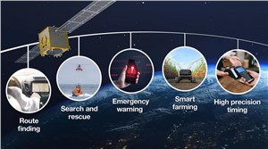
Galileo’s most widely used application is route finding and timing information, providing popular services such as real-time traffic conditions and estimated arrival times, making the European road network safer and traffic more efficient. As cars become more connected and automated driving develops, information provided by Galileo is key to critical safety applications such as stability control, anti-lock braking systems or smart mobility.
Critical emergency services benefit from Galileo for search and rescue missions. The system is widely used to locate life rafts lost at sea or to keep track of explorers heading to little-known parts of the world. It has a real impact by reducing rescue time. If someone is lost, the average time it takes to locate them is reduced from three hours to just ten minutes once the distress beacon is activated.**
In response to the increasing number of natural disasters, the European Union Space Programme is developing new services such as the Galileo Emergency Warning Satellite Service to save lives and protect property. Galileo’s satellites can transmit real-time information about disasters and emergencies directly to smartphones, as well as instructions to follow. This can be particularly useful when traditional terrestrial warning systems are unavailable due to poor mobile signals, heavy network traffic or infrastructure damage.
As the world's population continues to grow, agriculture will face growing demand for food while meeting its climate obligations. Part of the answer comes from navigation satellites. By combining precise mapping of fields with satellite imagery and an input modulation tool onboard tractors, it is possible to apply fertiliser only to areas that need them. As automation techniques evolve, intelligent robots guided by satellite geolocalisation will help farmers to work more efficiently, to avoid overlap.
In addition to navigation, Galileo’s high-precision timing signals are essential for applications such as telecommunications or financial transactions in order to ensure the integrity of data transmission.
Airbus at the forefront of European Galileo
Since Galileo’s inception, in support of the programme Airbus has provided major system expertise to the European Space Agency, the European GNSS Agency and the European Union.
Airbus engineers’ involvement goes back to 2005, starting with two test satellites: GIOVE-A built by Surrey Satellite Technology Ltd (SSTL) and GIOVE-B built by Airbus. The four in orbit validation satellites which followed were also built by Airbus and paved the way for the first ground-based positioning exclusively using the Galileo system.
Until 2018, Airbus was the prime contractor for the ground control infrastructure of the satellite navigation system, which oversees day-to-day control of all Galileo satellites in orbit.
In December 2023 Airbus started production of the Galileo Second Generation satellites and recently successfully achieved the satellite Critical Design Review (CDR). This technical milestone, which allows the design and technology to be frozen, means that the satellite is ready for full production.
In parallel, Airbus is developing the third generation of the EGNOS system (European Geostationary Navigation Overlay Service), which will further enhance GNSS performance for safety-critical applications such as aircraft landing, or maritime navigation through narrow channels.
Source : Airbus Defense and Space

Related Studies


